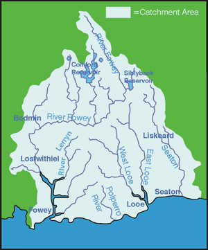
River Catchments - SEATON
The Seaton is a small lively river, stemming from Bodmin Moor at a height of 370m and flowing in the direction of Hessenford, before entering the sea at Seaton. The total length of the main river is approximately 17km. The underlying geology of the catchment is predominantly made up of slates and shale which tend to shed water rather than infiltrate it. Heavy rain leads to rapidly increasing flow rates which are then dissipated by the floodplain in the lower reaches.
The river valley is narrow and steep with the main channel in the lower reaches having undergone extensive channelisation, leading to the river becoming unnaturally straight and deep. Below Hessenford, the river widens and a distinct floodplain has developed up to 100m wide.
The Seaton valley contains several wetland features such as spring-fed wet floodplain woodlands which are rare habitats within the UK. Elsewhere, the catchment is characterised by low intensity agriculture and forestry.
The headwaters of the River Seaton suffer from chronic Copper and possibly Aluminium pollution from washings from historic mining operations up stream at Caradon. This results in a low in-stream invertebrate population and consequently a small Brown Trout population.
A total of 23 land management plans have been written in this catchment covering an area of 1,371 hectares and 6.2km of grant assisted fencing installed. Most of the riparian corridor in the lower catchment is Duchy controlled Forestry. Riparian woodland plans have been prepared for all the relevant sections focusing on tackling over shading and erosion of the riverbanks. Riverwise plans have been completed for the Liskeard and District Angling Club giving advice on best practice for the future management of the riparian corridor. Work in the catchment has involved liaison with a number of bodies, including Caradon District Council, Cornwall Wildlife Trust, Duchy of Cornwall, English Nature, Environment Agency, Forestry Agencies, Fowey Harbour Commissioners, Angling Clubs, Imerys and the Lostwithiel Town Forum.
