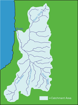
River Catchments - NEET and STRAT
The River Neet is a tributary of the River Strat which reaches the sea at Bude, a popular holiday destination and seaside resort on the North Cornish coast. Collectively, the Strat and Neet catchments drain an area of approximately 133.5km2, characterised by extensively drained agricultural land although some Culm grassland can still be found in the upper reaches.
The Strat and Neet rivers are not long, measuring 12.7 and 10.5 miles respectively, and are characterised by very quick response times to rainfall events. As a consequence, flooding can be a problem with extensive flood defence schemes being in place at Bude and Helebridge.
Land use within the catchment is dominated by intensive agricultural production. The upper reaches of the Strat are predominantly farmed by beef and sheep enterprises; elsewhere all types of farming including dairy and arable. River bank damage by livestock is evident throughout the catchment, leading to large amounts of sediment entering the rivers which is thought to be having a significant detrimental effect on Salmonid spawning grounds. High nutrient loadings have also been recorded on the River Neet, especially around Helebridge, leading to concerns over water quality.
There are currently no salmon present in either the Neet of the Strat although both rivers have populations of sea trout, brown trout, lamprey, eel, bullhead, minnow and stone loach.
The main river stems of the two rivers meet below the village of Marhamchurch, to the South of Bude, and enter the Bude Canal before rejoining the original channel over a wear. Two of the streams, the East Week and Jacob Streams, were severely impacted by the flooding that occurred around the North Cornwall coast on the 16th August 2004 manifesting itself in the flooding and destruction in Boscastle and Crackington Haven.
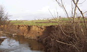
Although not as severe, the floods along the River Neet scoured out the channel and created water levels 3 metres above the top of the river bank. A rolling wall of water some 2 metres deep flowed along the flood plain below the village of Marhamchurch. The well located and newly erected grant aided fences along the river, in the main, survived, although its was interesting to note that existing fences across the main flow were destroyed, even where they were protected by hedges.
At the end of the Cornwall Rivers Project there have been 59 farm visits resulting in farm plans covering a total of 3,841 hectares and advice covering 93 kilometres of river and stream. A further 23 farmers were offered visits but declined. The farms ranged in size from smallholdings of 2 hectares up to large stock farms of 280 hectares. The farms tended to be stock farms with whatever arable grown being used for the farm’s own feed, with the straw utilised for bedding. The largest dairy farm carried 300 cows and the smallest milking only 35 cows.
Unrestricted access to the watercourses by stock, particularly cattle, was the most common issue found on farms. These were eroding the banks of the streams, silting up spawning gravels and carrying nutrients into the water which enriches the streams. Vertical banks with bare soils are common. The build up of debris dams in the previous years also contributed to the ‘Boscastle’ event flooding in the Neet and Strat, backing up the water and when this was released the tree trunks and other debris exacerbated the damage. A number of farms visited before the flood were advised to remove some of the worst debris dams but few if any had a chance to do so before the flooding.
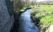
The Neet and Strat have not been targeted as regularly by other schemes and hence there was much potential for restoring the watercourse by fencing. A far greater proportion of the fencing grant pool was spent here (13%), installing some 22.5 Kilometres of fencing to help protect the river banks from erosion and increasing the habitat value along the banks. Along with advice on pollution control, fertiliser and manure best practice, soil testing and loss prevention, the watercourses will benefit and fisheries will be improved.
Other advice given included alternative watering for stock, guttering, clean and dirty water separation, tourism grants, selling fishing on lakes, pond advice, invasive weed control, woodland grants, as well as diversification information on garlic growing, coppicing, and wildflower meadow restoration.
We offered advice and grant to set up a superb demonstration site and public access area on the River Strat below Marhamchurch along the Hele Valley Trail. A farm walk was held before the site was finished and a very successful opening day with around 120 people attending was held by the owners. The local community has given a great deal of positive feed back about the site.