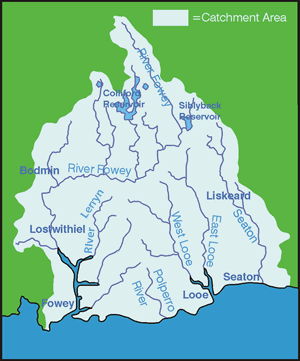
River Catchments - FOWEY and LERRYN
The River Fowey is one of the largest river catchments in south Cornwall, draining an area of approximately 177.5km² from central and southern Bodmin Moor. Importantly, the catchment includes two strategic reservoirs - Colliford and Siblyback - which supply water to a large part of the county's population. The river rises on Bodmin Moor at a height of 290m, flowing in a southerly direction for approximately 35km before reaching the tidal limit at Lostwithiel. The estuary continues for a further 9km before reaching the coast at Fowey town. There are several tributaries that enter the Fowey estuary, the largest of which is the River Lerryn.
The geology of the Fowey catchment varies from igneous granite on Bodmin Moor, through to Devonian slates in the middle reaches and Straddon grits and Meadford beds in the lower part of the catchment.
Copper and china clay mining have been major activities within the catchment, leading to contamination from metalliferous compounds and sediment. Although contamination levels are no longer considered to cause major water quality problems, disused china clay mines continue to act as a source of suspended solids.
Over 98 land management plans have been written for landowners, riparian owners and angling clubs in the Fowey and Lerryn catchments, covering an area of 4,967 hectares. In the Fowey catchment alone, some 15.15 km of riverbank has been fenced to protect the banks and downstream fishery.
Upper Fowey - Previous land drainage works on the headwaters of the Fowey opened sand lenses and resulted in sand intrusion into the river. This resulted in the smothering of cobbles, creating problems within Salmonid spawning areas, filling and shallowing of holding pools and a potential increase of sedimentation of the Fowey estuary. No farm visits were initiated above Palmers Bridge, Bolventor owing to outstanding EA litigation issues; however, friendly contacts have been made above Palmers Bridge.
Farm visits were carried out in the Draynes Valley with the majority of farms contacted. Issues of invasive weeds are prominent (Himalayan Balsam, Japanese Knotweed and Hemlock Water Dropwort) and can be seen all along the river edge from the road. Liaison and work with the FRA in the Draynes spawning sanctuary resulted in continuing Hemlock pulling and gravel cleaning together with 3 new drinking points emplaced.
Trenant Water - Evaluation of sustainable future options for redundant clay pits resulted in a major scoping report for Park Pit. This included reviewing overflow engineering to maintain appropriate water levels in the pit, reducing erosion and improving ecology and habitat together with appropriate management of the actual pit and adjoining leat riparian zone to benefit wildlife and fisheries. Liaison continues with Imerys, the EA & FRA.
Middle/Lower Fowey - Riverwise plans have been completed for virtually all riparian owners or tenants on the main river including Liskeard and District Angling Club, Wainsford Fishery, Newbridge Angling Syndicate, Glynn Valley Fishing Syndicate, Lanhydock Fishing Association and Lostwithiel Fishing Club totalling in excess of 17kms of main river. Fisheries have been improved with branch trimming out for casting areas and productivity together with fencing to protect the banks in many places.
The Lostwithiel Town Forum are planning a major regeneration project regarding development and management of the town, riverside parks and intertidal wetlands to enhance public and disabled access, education, wildlife and the fishery. A scoping Riverwise plan for the Town Forum has been prepared covering 3km of river from Second Island Park through Lostwithiel to Shirehall Moor. This River Plan has been unanimously adopted by Lostwithiel Town Forum and is now being used as a “roadmap” to detail future proposals within the Coastal and Market Town Initiative. Farm visits to farmers in the Respryn area resulted in more practical measures to prevent inputs to the river and erosion control.
St.Neot Water - Issues have arisen in connection with water transfer and abstraction between Colliford Lake and Restormel affecting water quality, temperature and chemical composition; effects have been noted downstream from St.Neot foot, causing turbidity. This has led to certain stretches of the Fowey, in particular at Wainsford, becoming ‘unfishable’ as salmonids continue their run to Golitha Falls, avoiding these unfavourable conditions. These issues were raised at the CAMS stakeholder meeting and also the ‘waterbank’ potential at Colliford is now under review.
Warleggan and Dewey - Erosion from disused pit spoil heaps at Glynn Valley Works causing significant point sand intrusion into the Warleggan River has been tackled with control measures such as willow fascine placement, fencing and hydroseeding in partnership with EA, FRA and Imerys. Hawks Tor pit continues as a supplementary Salmonid parr rearing water managed by FRA/Imerys utilising advice from WRT/EA. Management plans for Warleggan Marsh and Cardinham Moor (485ha) have been completed resulting in a CSS application for the common being submitted. The majority of the Dewey has been fenced to reduce stock access to the river.
River Lerryn near Lostwithiel - The landscape of the catchment is characterised by heathland, moorland and rough pasture in the upper reaches and broadleaf, coniferous and mixed plantation woodland in the middle and lower sections. The majority of the catchment is rural, the only notable urban areas being Lostwithiel and Fowey town.
There are 4 SSSIs within the catchment, in addition to the majority of the upper catchment being designated as an Area of Great Scientific Value (AGSV) and also an Area of Great Historical Value (AGHV).
Several farm plans have been written within the sub catchment covering a total of 1,260 hectares. Eleven km of watercourses have been advised upon. The main recommendations have been for optimising fertiliser applications, soil loss and fencing. Over 3500 metres of fencing has been grant funded and completed.