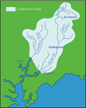
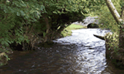
River Catchments - FAL and TRESILLIAN
The River Fal is approximately 29km in length. Starting at Goss Moor, the river passes through farmland and an intensive china clay mining area before emptying into the Fal estuary (a candidate Special Area of Conservation under the EU Habitats Directive). The Fal Estuary is a 'drowned river' (ria), and is the third largest natural harbour in the world; it is also an important shellfish fishery and is renowned for its oyster beds.
Goss Moor is a key area for wildlife and much of it is a National Nature Reserve, a designation arising from its unique wetland habitat including fen meadow and wet heath. There are a wide variety of notable species present in the catchment including bullheads, eels, and brook lampreys in addition to populations of brown trout, sea-trout and salmon, the latter featuring more in the Tresillian than the Fal.
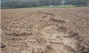
The predominant agricultural activity is dairy farming with mixed farming and rough grazing taking place on the poorer land; there is also some horticulture. A total of 86 farms have been visited during CRP covering an area of 7,078 hectares and 185km of waterways from Main River to the smallest of streams and ditches. Significant advice was offered on managing nutrients (both optimising fertiliser applications and managing manures to maximise their nutrient value) and minimising soil erosion; one particular farm has been used as a case study:
Other activities in the catchments during the project included:
- A family river walk with 23 attendees along the Fal from Tregony to Golden Mill
- The Grampound with Creed Parish Council is continuing to work with The Westcountry Rivers Trust and Trewithen Estate to establish a footpath along the Fal from Grampound to Golden Mill and has installed a CRP demonstration site
- An Integrated River Basin Resource Management Plan has been written for IMERYS to provide advice on the habitat management of the Fal
- The establishment of 4 fishing beats under Angling 2000 at Golden Mill, Grogarth, Geens Mill and Tregeagle