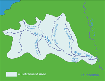
River Catchments - OTTERY
With a length of 33km, the River Ottery drains an area of 124.5km2 and forms one of the main sub-catchments of the Tamar system. Due to heavy impermeable clay soils and low permeability and porosity within the underlying geology (mostly shale), groundwater storage within the catchment is limited and flood risk is high, particularly around Caudworthy Water and Bolgate.
Historically, mining in the Ottery and Canworthy headwaters has lead to an increase in mineral levels in the river, accentuated by rapid run-off from the land. Excess mineral loadings have led to fish kills in the past, the most recent event taking place in the Autumn of 1995.
Most of the area consists of large specialist dairy farms (especially in the upper reaches) although cattle and sheep can be found at the downstream end. The main arable crop is maize in addition to a little cereal growing. There are five SSSI's in the Ottery catchment including the Ottery Valley SSSI in the headwaters which consists of 33ha of rapidly diminishing culm habitat. The catchment also hosts 5 CNCs, 1 Special Historic Landscape site and a proposed Area of Great Landscape Value (AGLV).
The Ottery supports a broad range of wildlife including populations of trout and migratory fish, otters, kingfishers, sand martins, dippers, curlews, snipe and the marsh fritillary butterfly.
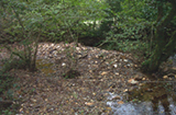
There have been 68 farm visits resulting in farm plans covering a total of 5,064 hectares and surveying of 114 kilometres of river and stream. A further 10 farmers were offered visits but declined. The farms tended to be larger, on average, than those in the nearby River Neet catchment but were predominantly stock farms with dairy farms more prevalent. The farms ranged in size from small holdings up to 350 hectares and dairy herds ranged from 60 to 200 animals. As with the River Neet, the western headwaters were severely affected by the floods which hit the North Cornwall Coast where some 8 inches of rain was recorded in 4 hours. The headwaters of the Ottery that rise at Marshgate and Otterham were the most severely affected with debris heights in the bankside trees 3m above the river bank. Huge amounts of river gravels were gouged out of the channels and deposited in woodland beside the watercourses and severe flooding occurred on the Canworthy Water. A number of farmers trying to retrieve machinery whilst fencing along the river had to be rescued by helicopter after getting trapped by the floods.
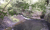
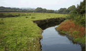
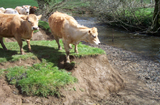
Direct cattle access to the river banks was found to be the main problem affecting the river; eroding banks occurred where stock accessed the watercourse to drink and also grazing tight to the river’s edge reduces the root depth of grass and other vegetation that might otherwise buffer the erosive power of the river. Soil loss from maize fields and diffuse pollution from farmsteads were also major influences on the tributaries of the Ottery.
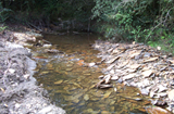
A total length of just over 26 kilometres of fencing was grant aided along the main river and its tributaries (15.5% of all fencing) helping to protect the watercourses. Three new beats for Angling 2000 were created allowing new fishing on 4 km of the main River Ottery. The floods have cleaned the gravels in the rivers and a good spawning habitat should help future stocks of fish.
Advice was also given on protecting soils, reducing farmyard pollution best practice for fertilisers and manures, tourism, marketing fishing, woodland grants, pond advice and recognising invasive weeds.