east
and west looe
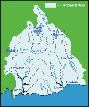 Together
with the Seaton and the Fowey catchments, the East and West Looe
catchment rises at approximately 300m and drains an area of south
east Cornwall from the southern slopes of Bodmin Moor to the south
coast. From the headwaters to the estuary, both East and West Looe
rivers fall steeply at 13m/km and 10m/km respectively and are subject
to rapid rises and falls in water levels after periods of rainfall. Together
with the Seaton and the Fowey catchments, the East and West Looe
catchment rises at approximately 300m and drains an area of south
east Cornwall from the southern slopes of Bodmin Moor to the south
coast. From the headwaters to the estuary, both East and West Looe
rivers fall steeply at 13m/km and 10m/km respectively and are subject
to rapid rises and falls in water levels after periods of rainfall.
The catchment is very rural in
character, ranging from open moorland to rolling hills intersected
by steep sided river valleys.
Historically, mining activity
was widespread in the upper catchment which has left a legacy of
abandoned mines and workings throughout the area.
The underlying geology within
the Looe catchment is characterised by Devonian sedimentary rocks
(slates, shales and thin limestones) with the bedrock forming one
of the few groundwater aquifer reserves found in Cornwall.
In addition to supporting numerous
drinking water supplies in the catchment, these groundwater supplies
facilitate river baseflow during period of low rainfall. Due to
the shallow water tables and low porosity of the geology, groundwater
reserves are highly vulnerable to contamination from the escape
of pollutants into the soil.
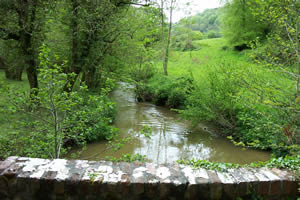
| |
| West
Looe from Sowdens Bridge downstream |
Bodmin Moor and the coast from
Fowey to West Looe are Areas Of Outstanding Natural Beauty (AONB)
whilst the Looe valley is a Special Area of Great
Landscape Value (SAGLV). A wide
variety of wildlife can be found within the Looe catchment including
otters, dippers, kingfishers, grey herons, peregrines, merlins,
hen harriers, golden plover and the marsh fritillary.
|